
 |
| Garmin GPS III+ mounted on Land Rover dash. |
My old GPS is currently abandoned in a cupboard drawer waiting for a need to be turned on. It's a Garmin III+ with the world basemap along with limited coverage of Africa. It uses a serial cable to download and upload the data to a computer (which PC has a serial connector now?).
The Garmin was used daily during my trans-Africa trip, with the main screen set to display vital information like voltage, altitude, average speed, sunset and distance traveled.
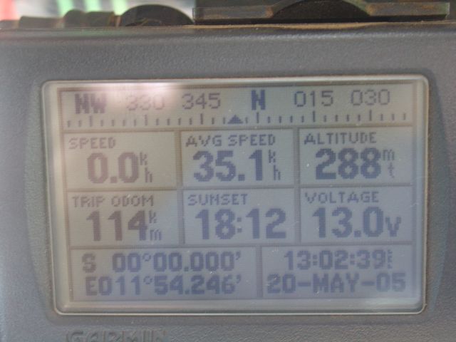 |
| Garmin GPS III+ |
Perhaps, for my sanity, I need to leave SatNav behind and begin to explore those minor roads, bravely going were hardly any SatNav's dare... I need to get lost again, and to retrace my vehicle tracks. I need to ponder maps & routes. Time to leave SatNav at home...
Thoughts and comments always welcome...
I hear ya'. Having the GPS tell me what to do seems an extension of the work-world to me, and snuffs out any adventure of exploration.
ReplyDeleteSo I've always preferred to use my GPS to tell me where I *am* and where I've been, rather than where I should go. I keep the GPS zoomed to street level detail and refer to the map and compass on top of my motorcycle tank bag for the "big picture".
(This technique must come from growing up with video games...)
You can see the view from the saddle here:
http://bit.ly/gYcDBR
This method works for me because I travel without pre-planning any routes and I'm careful to avoid having to be anywhere at a certain time... I'll have a few landmarks to hit, 'Chichen Itza' or 'any small fishing village' but generally it will just be a direction, 'west' or 'along the Pacific' .
I find this also avoids the frustration of goofy GPS instructions like U-turns on a divided highway. Besides, coverage is so patchy and inaccurate in places like Central America the GPS isn't capable of holding your hand.
anyway, map and compass is just fun. I remember kids in Guatemala coming up to check out the motorcycle. They weren't impressed by the GPS - they thought it was a phone - but they were fascinated by the compass! Kids always know what's cool.
Magellan Pioneer was my choice, I,v just switchd it on and it still works!
ReplyDeleteCan you all remember life before GPS ?